General
-
 1974 ANZAC Day March, The Gap, led by the Pipe Band.
 -
 1974 ANZAC Day Service, Settlement Road, The Gap.
 -
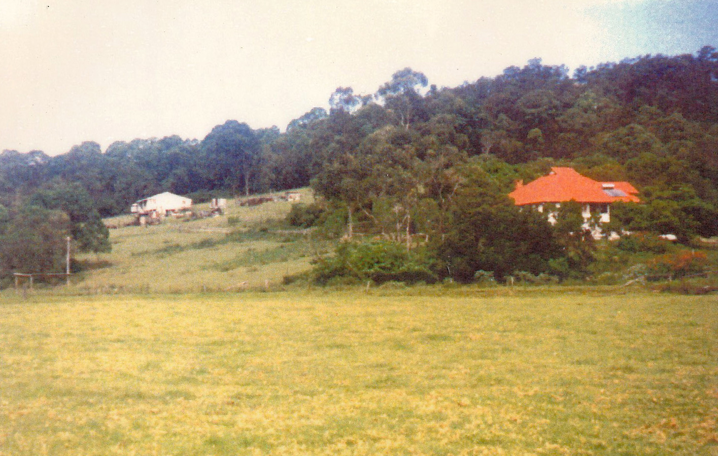
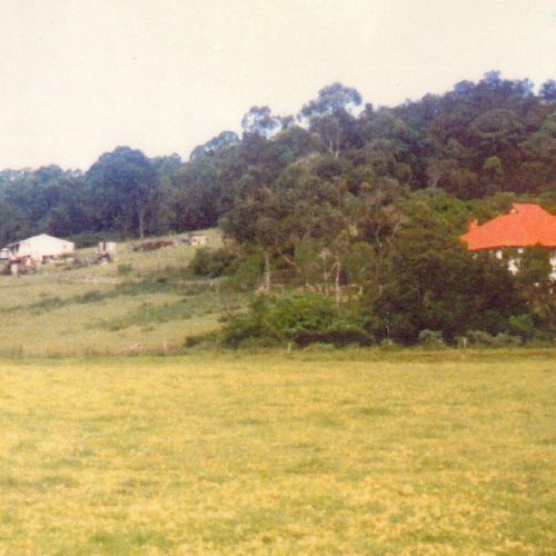
 The view from the back of Bill Harvey's property in Moggill Road and looking towards Herb Wilson's property. Bill Harvey's farm buildings are in the foreground and in the background on Moggill Road are from left, Wilson's house, garage and cow bails, circa 1990.
Bill Harvey’s property
The view from the back of Bill Harvey’s property in Moggill Road and looking towards Herb Wilson’s property. Bill Harvey’s farm buildings are in the foreground and in the background on Moggill Road are from left, Wilson’s house, garage and cow bails, circa 1990.
Quick ViewDetails -
 Catherine and Janet Johnston relaxing on some rocks in the creek under Walton Bridge, The Gap, circa 1970.
Catherine and Janet Johnston at Walton Bridge 1970
Catherine and Janet Johnston relaxing on some rocks in the creek under Walton Bridge, The Gap, circa 1970.
Quick ViewDetails -
 A very proud Claude Mason who had his Jam Factory 200 yards on left past Bennetts Road inbound in Waterworks Road, displays his wares at "Wittonga" Park at 1988 Bi-Centenary Celebrations.
Claude Mason 1988
A very proud Claude Mason who had his Jam Factory 200 yards on left past Bennetts Road inbound in Waterworks Road, displays his wares at “Wittonga” Park at 1988 Bi-Centenary Celebrations.
Quick ViewDetails -
 Early days at Red Hill looking west to the ranges and The Gap.Quick ViewDetails
 -
 Interior of the Elita Theatre Ashgrove, circa 1951.
 -
 Elita Theatre - 12th March 1954.
 -
 Elita Theatre Manager George Cuffe, January 1956.
 -
 Work crew installing Miracle Mirror Screen 29, Nov 1955.
 -

Young people have fun in Enoggera Creek.
-
 The Gap 1974 Jan after the flood. The R.S.L. Club, Settlement Rd. The cars are parked facing Settlement Rd. Fish Creek was later redirected, water level up to window sills.
Floods 1974
The Gap 1974 Jan after the flood. The R.S.L. Club, Settlement Rd. The cars are parked facing Settlement Rd. Fish Creek was later redirected, water level up to window sills.
Quick ViewDetails -
 Ros Williams (on the right) standing in the driveway of her property at 340 Payne Road, The Gap with her neighbour, surveying the flood waters of 1974. School Rd bridge is underwater.
Floods 1974
Ros Williams (on the right) standing in the driveway of her property at 340 Payne Road, The Gap with her neighbour, surveying the flood waters of 1974. School Rd bridge is underwater.
Quick ViewDetails -
 1974 floods, a truck is forging its way through the flood waters outbound in Payne Road just past the School Road bridge.
Floods 1974
1974 floods, a truck is forging its way through the flood waters outbound in Payne Road just past the School Road bridge.
Quick ViewDetails -
 The flood repair work on School Road Bridge viewed from the Williams driveway at 340 Payne Road The Gap, after 1974 Flood.
Floods 1974 Repairs
The flood repair work on School Road Bridge viewed from the Williams driveway at 340 Payne Road The Gap, after 1974 Flood.
Quick ViewDetails -
 Work crews doing temporary bridge repairs on School Road, The Gap after the record overnight flood waters in January 1974.
Floods 1974 School Road
Work crews doing temporary bridge repairs on School Road, The Gap after the record overnight flood waters in January 1974.
Quick ViewDetails -
 Outbound view of the flood damage sustained overnight at the peak of the January 1974 floods at the Payne Road end of the School Road bridge.
Floods 1974 School Road bridge
Outbound view of the flood damage sustained overnight at the peak of the January 1974 floods at the Payne Road end of the School Road bridge.
Quick ViewDetails -
 The southern approach to the School Road bridge, The Gap is underwater in the 1974 floods and the community water stand pipe has burst.
Floods 1974 School Road bridge
The southern approach to the School Road bridge, The Gap is underwater in the 1974 floods and the community water stand pipe has burst.
Quick ViewDetails -
 Cleaning up around the R.S.L. Building on Settlement Road, next to Fish Creek, after the 1974 floods.
Floods 1974 Settlement Road
Cleaning up around the R.S.L. Building on Settlement Road, next to Fish Creek, after the 1974 floods.
Quick ViewDetails -
 A foot bridge was built by residents in about 1965, to enable women with strollers to cross the creek to reach the shop and the bus. Note the high level of the water, it has never remained at that level since the dam wall was raised. Humorous anecdote. While the working bee was busy spanning the creek with timbers, a little girl piped up, "Mummy Mummy, Daddy's getting his feet wet." Daddy was up to his chin in the water, and we all had a good laugh. – Richard Speechley
Foot Bridge 1965
A foot bridge was built by residents in about 1965, to enable women with strollers to cross the creek to reach the shop and the bus. Note the high level of the water, it has never remained at that level since the dam wall was raised.
Humorous anecdote. While the working bee was busy spanning the creek with timbers, a little girl piped up, “Mummy Mummy, Daddy’s getting his feet wet.” Daddy was up to his chin in the water, and we all had a good laugh.
– Richard Speechley
Quick ViewDetails -

Young Beverley Wright with some beloved chicks on her father's (Fred Wright) poultry farm in Settlement Road, The Gap.
Fred Wright Poultry Farm
Young Beverley Wright with some beloved chicks on her father’s (Fred Wright) poultry farm in Settlement Road, The Gap.
Quick ViewDetails -
 Beth Hedley and John Diprose at their wedding day on 2nd March 1963, with The Gap Methodist Junior Choir. This was the first wedding ceremony to be conducted in the new brick church.
Gap Methodist Junior Choir
Beth Hedley and John Diprose at their wedding day on 2nd March 1963, with The Gap Methodist Junior Choir. This was the first wedding ceremony to be conducted in the new brick church.
Quick ViewDetails -
 Early owners and family of Greenlanes Swimming Pool enjoy the water ~ Circa 1960. Later to become Taylor Range Country Club in 1971.
Greenlanes Swimming Pool 1960
Early owners and family of Greenlanes Swimming Pool enjoy the water ~ Circa 1960. Later to become Taylor Range Country Club in 1971.
Quick ViewDetails -
 Herb Wilson's house located on Moggill Road, circa 1990.
 -
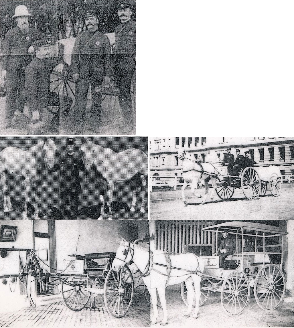
 The founder of the Queensland Ambulance Transport Brigade, 1892. Seymour C. Warrian Taken from “Notes on the Inauguration of The Queensland Ambulance Transport Brigade”. From September 1892 to January 1897.
History of Transport – QLD Ambulance
The founder of the Queensland Ambulance Transport Brigade, 1892.
Seymour C. WarrianTaken from “Notes on the Inauguration of The Queensland Ambulance Transport Brigade”. From September 1892 to January 1897.
Quick ViewDetails -
 Mr John Andersley, driver, and fellow officers aboard the first motorised vehicle, 1908.
History of Transport – QLD Ambulance
Mr John Andersley, driver, and fellow officers aboard the first motorised vehicle, 1908.
Quick ViewDetails -
 1. First Litter & crew, Senior Office J.W. Taylor (in helmet) 2. The Sulky & Litter. In 1897 the first sulky, drawn by a white pony, was introduced. The litter was taken out behind the sulky and wheeled back to Hospital by the Bearers.. The Ambulance wagonette was also introduced about this time. 3. A well equipped plant room at the turn of the century.
History of Transport – QLD Ambulance
1. First Litter & crew, Senior Office J.W. Taylor (in helmet)
2. The Sulky & Litter. In 1897 the first sulky, drawn by a white pony, was introduced. The litter was taken out behind the sulky and wheeled back to Hospital by the Bearers.. The Ambulance wagonette was also introduced about this time.
3. A well equipped plant room at the turn of the century.
Quick ViewDetails -
 1. The Motor Car – Ambulance In 1908 the Motor Vehicle was introduced into the Service, note that the litter was still transported out, to be wheeled on the return to Hospital. The first Motor Vehicle Body was made by the same firm that built the first Litter in 1893 – The Federal Carriage Co. 2. The Ambulance Vehicle Within several years motorised transport had improved so greatly that by the early 1900's Ambulance Transport was completely motorised. The litter was now obsolete. Image: Ford Motor Ambulance 3. The Latest in ambulance vehicles – 1974
History of Transport – QLD Ambulance
1. The Motor Car – Ambulance
In 1908 the Motor Vehicle was introduced into the Service, note that the litter was still transported out, to be wheeled on the return to Hospital.
The first Motor Vehicle Body was made by the same firm that built the first Litter in 1893 – The Federal Carriage Co.2. The Ambulance Vehicle
Within several years motorised transport had improved so greatly that by the early 1900's Ambulance Transport was completely motorised. The litter was now obsolete.
Image: Ford Motor Ambulance3. The Latest in ambulance vehicles – 1974
Quick ViewDetails -
 Looking west from 11 Laird Street, St Johns Wood from home of the Lake Family - Built 1935.
Lake Family Home
Looking west from 11 Laird Street, St Johns Wood from home of the Lake Family – Built 1935.
Quick ViewDetails -
 Looking north/west from 11 Laird Street, St Johns Wood Home of the Lake Family - built 1935.
Lake Family Home
Looking north/west from 11 Laird Street, St Johns Wood Home of the Lake Family – built 1935.
Quick ViewDetails -
 Looking north/west from 11 Laird Street, St Johns Wood Home of the Lake Family - Built 1935.
Lake Family Home View
Looking north/west from 11 Laird Street, St Johns Wood Home of the Lake Family – Built 1935.
Quick ViewDetails -
 Bill Harvey’s home in Moggill Road, circa 1990.Quick ViewDetails
 -
 The view from the paddock off Moggill Road, The Gap, with the homes of Dr Kay on the right and Bill Harvey on the left, circa 1990.
Moggill Road Paddock 1990
The view from the paddock off Moggill Road, The Gap, with the homes of Dr Kay on the right and Bill Harvey on the left, circa 1990.
Quick ViewDetails -
 Prior to development along Moggill Road, (Moggill meaning “Place of Lizards"). The old dairy shed on the farm of Frank and Harriet Wilson - circa 1960, prior to arrival of housing estates. The farm was situated on right between first and second dip in Moggill Road west of Payne Road. The home on hill in background is that of Bill and Jean Harvey.
Moggill Road prior to development
Prior to development along Moggill Road, (Moggill meaning “Place of Lizards”).
The old dairy shed on the farm of Frank and Harriet Wilson – circa 1960, prior to arrival of housing estates. The farm was situated on right between first and second dip in Moggill Road west of Payne Road. The home on hill in background is that of Bill and Jean Harvey.
Quick ViewDetails -
 The view from Low's hill looking towards the T.V. towers on Mt Cootha, circa 1960s. The red roofed house is Dr Kay’s on Kays Road and Bill Harvey’s home is behind and slightly uphill.
Moggill Road View 1960s
The view from Low’s hill looking towards the T.V. towers on Mt Cootha, circa 1960s. The red roofed house is Dr Kay’s on Kays Road and Bill Harvey’s home is behind and slightly uphill.
Quick ViewDetails -
 The view from Bill Harvey’s property looking towards Payne Road, circa 1990. The area to the right of the photo is the location of Parkside, Cootha and Easton Close (in 2001).
Moggill Road View 1990
The view from Bill Harvey’s property looking towards Payne Road, circa 1990. The area to the right of the photo is the location of Parkside, Cootha and Easton Close (in 2001).
Quick ViewDetails -
 Connie Carnegie (front left) and May Grimes (front right) with Matthew and Laura Symes behind Bill Harvey's home and looking towards Moggill Road, circa 1990.
Moggill Road View 1990
Connie Carnegie (front left) and May Grimes (front right) with Matthew and Laura Symes behind Bill Harvey’s home and looking towards Moggill Road, circa 1990.
Quick ViewDetails -
 A rainy day on the construction site of the new School Road bridge as viewed from the Williams driveway at 340 Payne Road. Circa 1995/6.
New School Road bridge 1995
A rainy day on the construction site of the new School Road bridge as viewed from the Williams driveway at 340 Payne Road. Circa 1995/6.
Quick ViewDetails -
 This home was the "Sheffield Family" home on right-hand bottom side of School Road just down from Waterworks Road. At the rear was a sawmill used in cutting local timber. Photograph - courtesy of the late Ruth Proctor who rented the home.
Sheffield Family home
This home was the “Sheffield Family” home on right-hand bottom side of School Road just down from Waterworks Road. At the rear was a sawmill used in cutting local timber. Photograph – courtesy of the late Ruth Proctor who rented the home.
Quick ViewDetails -
 Granite House, St Johns Wood, circa 1960. Photo taken looking south/west from 11 Laird Street
St John’s Wood Granite House
Granite House, St Johns Wood, circa 1960. Photo taken looking south/west from 11 Laird Street
Quick ViewDetails -
 The new R.S.L. building in Settlement Road, The Gap, viewed from Jack and Maureen Proctor's home on 8 April 1980 just after a car over over turned at the corner of Chaprowe Road (visible in the centre left of photo).
The Gap R.S.L. New Building
The new R.S.L. building in Settlement Road, The Gap, viewed from Jack and Maureen Proctor’s home on 8 April 1980 just after a car over over turned at the corner of Chaprowe Road (visible in the centre left of photo).
Quick ViewDetails -
 The old R.S.L. premises at Settlement Road Bridge, The Gap in the foreground with the new brick premises visible at the rear. Photographed in March 1980.
The Gap R.S.L. Old Building
The old R.S.L. premises at Settlement Road Bridge, The Gap in the foreground with the new brick premises visible at the rear. Photographed in March 1980.
Quick ViewDetails -
 Tom Cummins smoking a pipe with two lads, possibly his brothers. The son in law of Christian and Margaret Nielsen, Tom married Emily Nielsen.
Tom Cummins
Tom Cummins smoking a pipe with two lads, possibly his brothers. The son in law of Christian and Margaret Nielsen, Tom married Emily Nielsen.
Quick ViewDetails -
 View of the TV towers on Mt Cootha and from the home of Mervyn Kay at 181 Paynes Road, The Gap, circa 1960s.
View of Mt Cootha 1960s
View of the TV towers on Mt Cootha and from the home of Mervyn Kay at 181 Paynes Road, The Gap, circa 1960s.
Quick ViewDetails -
 This sweeping view of The Gap looking north is the result of joing 3 snaps taken by Don Trotman, architect, from the position of where the watertank now stands in Parkdale estate. At the time the hill was 22 feet higher. He and his wife Pam built their home in the foreground, Woodbine Street. Circa 1958.
View of The Gap 1958
This sweeping view of The Gap looking north is the result of joing 3 snaps taken by Don Trotman, architect, from the position of where the watertank now stands in Parkdale estate. At the time the hill was 22 feet higher. He and his wife Pam built their home in the foreground, Woodbine Street. Circa 1958.
Quick ViewDetails -
 Maureen and Reg Heyer with their children and friends under the arches at Walton Bridge, The Gap.
Walton Bridge
Maureen and Reg Heyer with their children and friends under the arches at Walton Bridge, The Gap.
Quick ViewDetails -
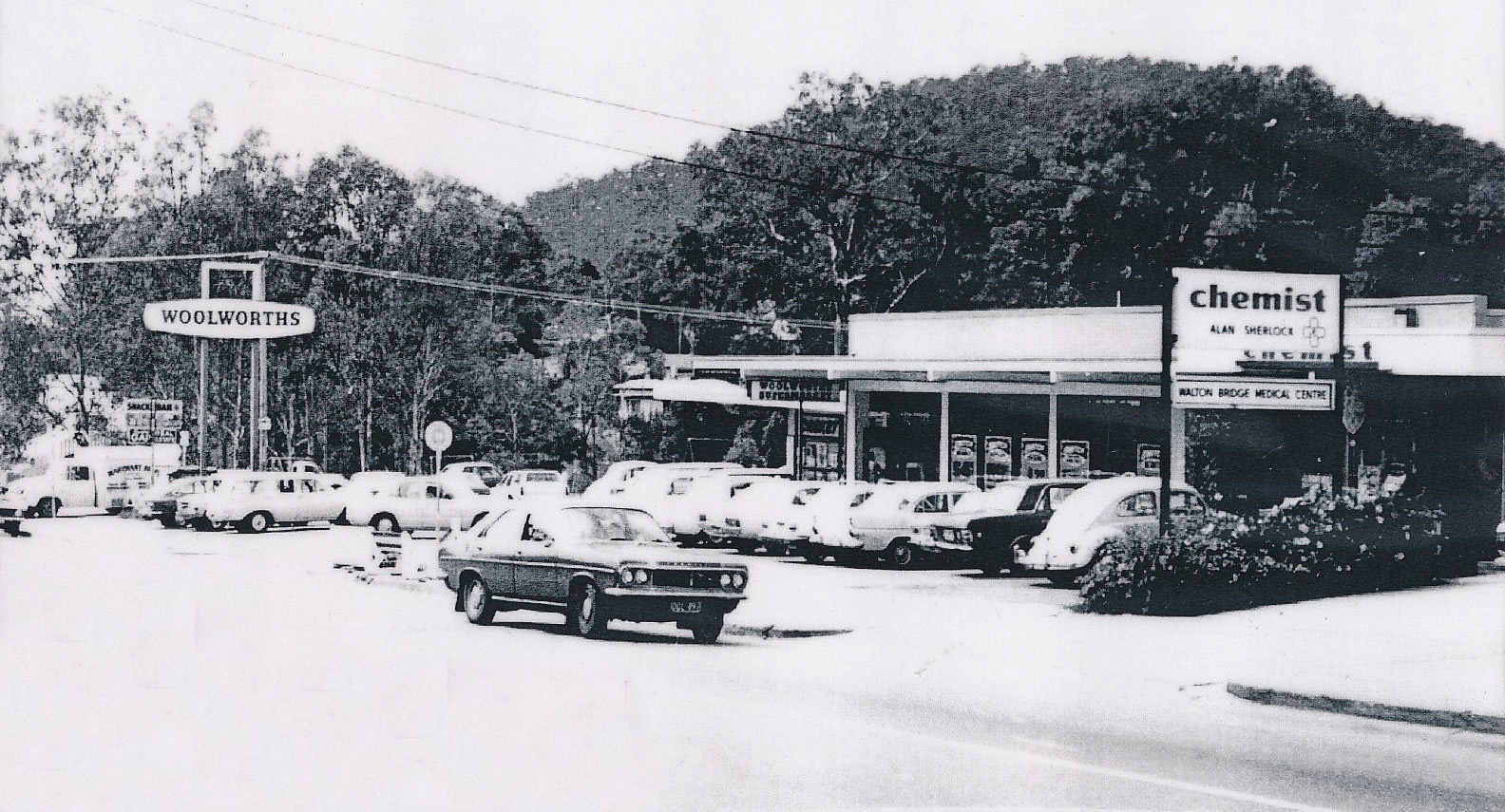
 Woolworths at Walton Bridge Shopping Centre, The Gap, circa 1977.
Walton Bridge Shopping Centre 1977
Woolworths at Walton Bridge Shopping Centre, The Gap, circa 1977.
Quick ViewDetails -
 Barry Park Shopping Centre, referred to by the locals as “Barry's", at Walton Bridge, The Gap, circa 1977.
Walton Bridge Shopping Centre 1977
Barry Park Shopping Centre, referred to by the locals as “Barry’s”, at Walton Bridge, The Gap, circa 1977.
Quick ViewDetails -
 Wilson's Farm (and pony), Moggill Road, The Gap. 1988.